TROPICAL WEATHER OUTLOOK
NWS NATIONAL HURRICANE CENTER MIAMI FL
800 PM EDT FRI JUN 22 2012
FOR THE NORTH ATLANTIC...CARIBBEAN SEA AND THE GULF OF MEXICO...

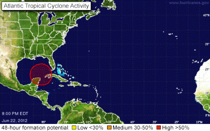
NOAA graphic
Satellite imagery and surface observations indicate that the circulation associated with the large surface low pressure area located about 100 miles north of the northeastern tip of the Yucatan Peninsula has continued to become better defined. Surface pressures are still falling across the area...and shower and thunderstorm activity has been steadily increasing over much of the central and eastern gulf of Mexico today. Environmental conditions are expected to remain conducive for a tropical depression to form during the next day or so as this large disturbance drifts slowly northward. This system has a high chance...80 percent...of becoming a tropical cyclone during the next 48 hours. Interests along the united states gulf coast should monitor the progress of this disturbance through the weekend. Heavy rains and localized flooding are possible across the Yucatan Peninsula...Western Cuba...and Southern Florida through Saturday. -National Hurricane Center, Miami
COASTAL HAZARD MESSAGE- NATIONAL WEATHER SERVICE MOBILE AL
346 PM CDT FRI JUN 22 2012...THERE IS A HIGH RISK FOR DANGEROUS RIP CURRENTS ALONG THE
BEACHES OF ALABAMA AND NORTHWEST FLORIDA THROUGH SUNDAY...
For the latest weather updates go to: http://www.nhc.noaa.gov/